
Page 10 - EMCORE Navigation & Inertial Sensing Brochure
P. 10
Ring Laser Gyro Battlefield INS
EMCORE’s product line now includes the advanced Ring Laser Gyro-based products of the former L3Harris Space & Navigation,
which has supplied the highest performance, reliability, and quality pointing and position capability for land navigation including
artillery/radar positioning & pointing systems and battlefield/artillery survey systems.
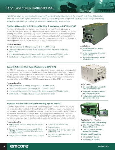
Position & Navigation Unit, Universal Position & Navigation Unit (PNU / UPNU)
The PNU / UPNU provides the Multiple Launch Rocket System (MLRS) and High-Mobility
Artillery Rocket System (HIMARS) programs with the highest performance, reliability and quality
pointing and position capability, paving the way for the future direction of the land navigation
systems. Utilizing advanced sensors, electronics, software, and aiding (GPS and odometer), the
PNU / UPNU family delivers precisely what the Army of tomorrow needs — a system designed to
remain operationally effective and affordable to support well into the future.
Features/Benefits
n High-performance RL-34 ring laser gyros (0.18 mils RMS sec lat) Applications
n Mobile multiple launch artillery
n Common architecture and components (Paladin, Firefinder, Air Surveillance Radar, rocket systems
IPADS CPNU)
n Aiming and navigation of launcher
n Impervious to jamming (inertial mode) and resistant to jamming (GPS-aided mode) ground vehicles
n Combat-proven, high-reliability MTBF and low Mean Time to Repair (MTTR) n High-precision pointing of launcher
pods and rockets
Dynamic Reference Unit-Hybrid Replacement (DRU-H-R)
The DRU-H-R is an advanced precision delivery subsystem that provides accurate vehicle position
and attitude data and operates on Paladin and Firefinder, both playing critical roles in support-
ing U.S. ground forces in all phases of active combat operations. The EMCORE S&N DRU-H-R
design upgraded system performance by using high accuracy, combat-proven inertial sensors
currently fielded on the MLRS and HIMARS weapon systems, and the IPADS survey system.
Features/Benefits
n High-performance RL-34 ring laser gyros (0.18 mils RMS sec lat) Applications
n Self-propelled howitzers, counter-fire
n Common architecture and components (MLRS, HIMARS, IPADS) radar, air surveillance radar
n Impervious to jamming (inertial mode) and resistant to jamming (GPS-aided mode) n Aiming and navigation of howitzer
n Combat-proven heritage; fully qualified/U.S. government tested and radar ground vehicles
n High-precision pointing of howitzer
gun tube and radar array
Improved Position and Azimuth Determining System (IPADS)
EMCORE’s Improved Position and Azimuth Determining System (IPADS) is an inertial surveying
system developed to meet today’s demanding U.S. Army and Marine Corps survey needs. Sur-
vey operations functionality, navigational accuracy, transportability, survivability and affordability
requirements drove the system design. IPADS provides significant enhancements for today’s
Army and Marine Corps survey teams with all components housed in a robust frame with easy
component access and stability, facilitating a two-person transfer between vehicles and aircraft.
Application/Specifications
Features/Benefits Survey Control Point (SCP) Accuracy
n High-precision common survey enables efficient n In-vehicle and offset survey n 3.6 m CEP, 1.6 m PE, 75 km radial
mass fires n Combat-proven distance (GPS-denied)
n Common architecture and components (MLRS, n High reliability MTBF, low Mean Time n 1.8 m CEP, 0.8 m PE, unlimited
HIMARS, Firefinder, Paladin and Long-Range Air to Repair (MTTR) distance (GPS-available)
Surveillance Radar)
n GPS, non-GPS and international Orienting Line (OL) Accuracy
n Navigation aids (compass rose and digital maps) versions available n 0.4 mils PE (GPS-denied)
n 0.2 mils PE (GPS-available)
>
10 emcore.com